

St Albans District Council Local Plan, Green Belt Review and Site Selection Updates.
by Akeem Iginla
The approach taken regarding the Green Belt Review by St Albans District Council has utilised learning from successful Examinations of Local Plans elsewhere as well as learning from those Examinations where there have been criticisms of approach to Green Belt technical work and / or the Local Plan approach to the Green Belt.
The Green Belt Review and Site Selection work are key parts of the evidence base supporting the new draft Local Plan. The Local Plan Advisory Group (LPAG) confirmed the approach to the Green Belt Review at its meeting on 18 January 2022 and agreed the approach to the Site Selection Methodology at its meeting on 14 June 2022.
The Council Planning Officers also consulted on the methodology for the Green Belt Review with neighbouring Councils and their numerous helpful feedbacks were taken into consideration. With considerable evidence and the whole draft Local Plan for Regulation 18 formal public consultation will be presented at the next Planning Policy and Climate Committee (PP&C) meeting
There are forthcoming important decisions regarding the new draft Local Plan due to go out to Regulation 18 public consultation on 12 July 2023. There are a number of Councillors on this new Planning Policy and Climate Committee who were not previously part of the Local Plan Advisory Group (LPAG).
In terms of the Spatial Strategy for St Albans City and District, it sets out Climate Change as a thread running throughout the Local Plan by promoting the use of renewable resources, reducing carbon emissions, protecting natural resources and reducing waste. Regarding growth, the Council noted that this will be located to make the most sustainable use of land in urban areas and then the Green Belt. The approach seeks to develop Brownfield Land first.
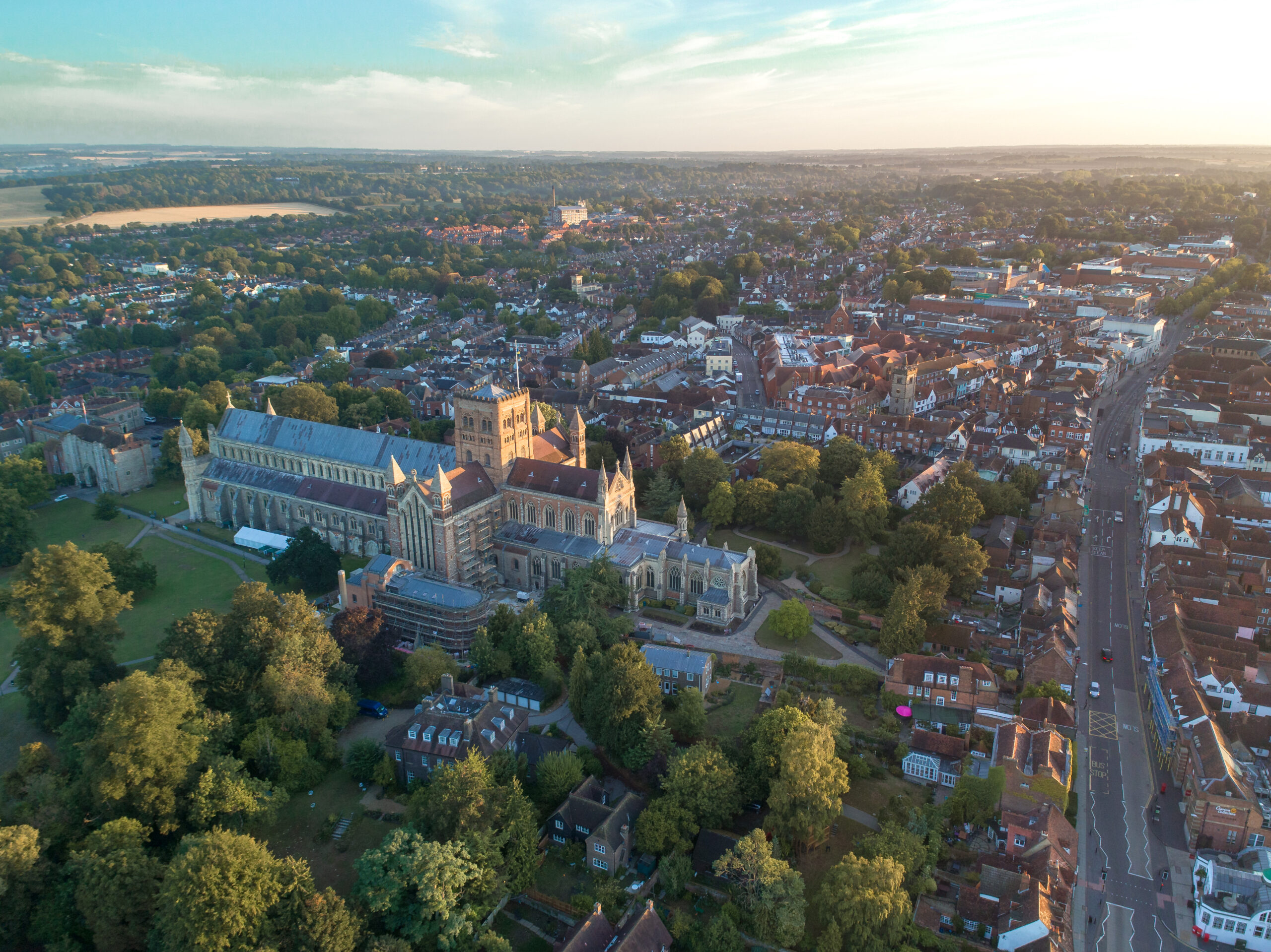
Over 81% of the District’s area is classified as Green Belt, some 13,141 hectares. The Green Belt are categorised as Broad Locations and Large, Medium and small Sites. These Broad locations are:
North Hemel Hempstead – as indicated in Figure 1, the Site is located to the northeast of Hemel Hempstead, a tier 1 settlement and forms part of the wider Hemel Garden Communities programme. It is proposed to provide approximately 1,250 dwellings to 2041 and beyond (approximately 250 homes to be delivered post 2041).
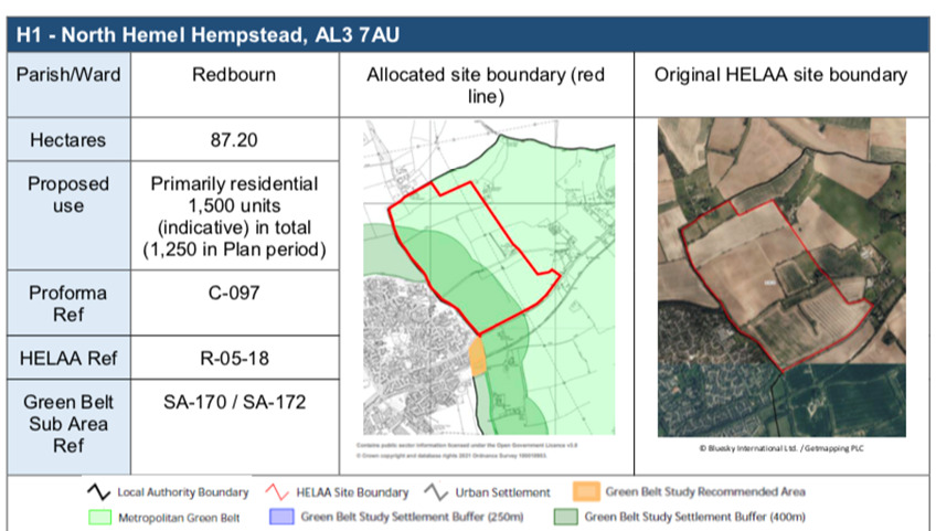
Figure 1: Proposed Site Allocation
Source: SDC
East Hemel Hempstead (North) – The site as indicated in Figure 2, is to the east of Hemel Hempstead, between B487 to the north, the M1 to the east and Punchbowl Lane to the south. The site is adjacent to Hemel Hempstead, a Tier 1 settlement, and forms part of the wider Hemel Garden Communities Programme. It is proposed to deliver approximately 1,335 dwellings to 2041 and beyond (approximately 265 homes to be delivered post 2041).
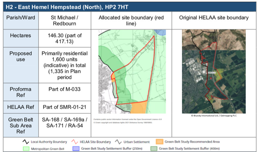
Figure 2: Proposed Site Allocation
Source: SDC
East Hemel Hempstead (Central) – The site as indicated in Figure 3, is approximately 120.50ha (part of 417.13 ha) employment Led Mixed Use (Enterprise Zone) and it’s situated to the east of Hemel Hempstead, between Punchbowl Lane to the north, the M1 to the east and the A414 to the south. The site is adjacent to Hemel Hempstead, a Tier 1 settlement, and forms part of the wider Hemel Garden Communities Programme.
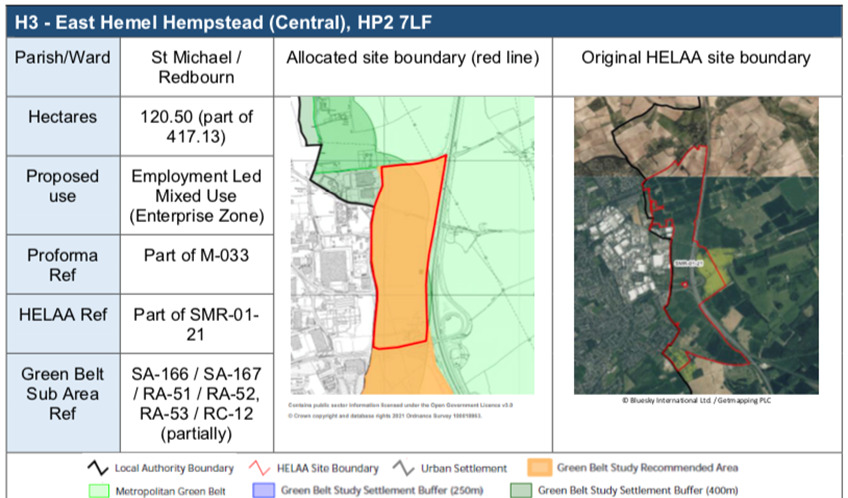
Figure 3: Proposed Site Allocation
Source: SDC
East Hemel Hempstead (South) – The site as indicated in Figure 4, is primarily residential 2,400 units (indicative) in total (2,165) in plan period), provision of 2,400 dwellings, situated to the east of Hemel Hempstead, between the A414 to the north, the M1 to the east and the A4147 to the south. The site is adjacent to Hemel Hempstead, a Tier 1 settlement and forms part of the wider Hemel Garden Communities Programme.
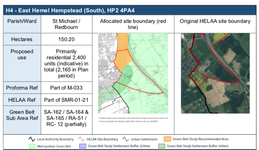
Figure 4: Proposed Site Allocation
Source: SDC
North St Albans –The site as indicated in Figure 5, is 46.75 ha, it is primarily residential 1,146 units (indicative) (this includes 150 from planning permission ref: 5/2021/0423).
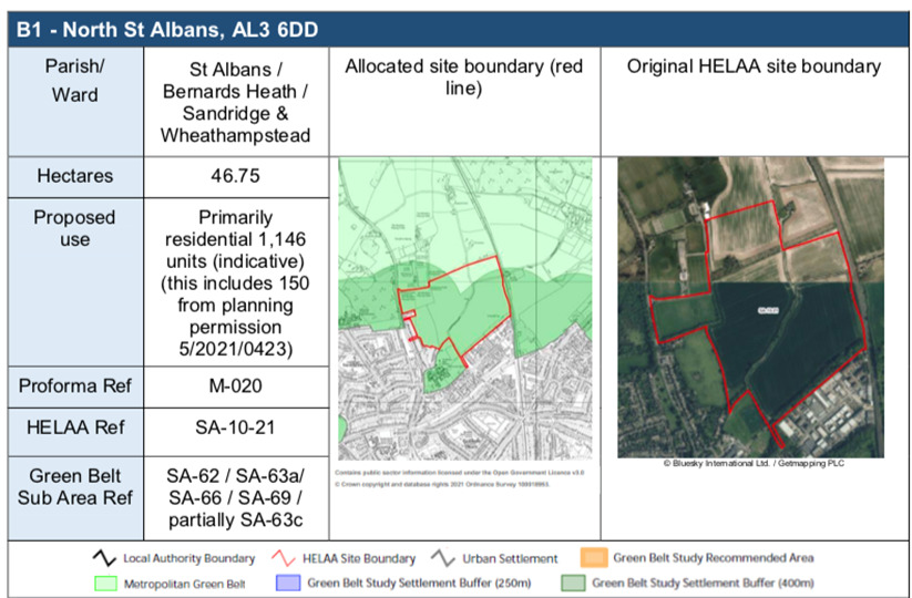
Figure 5: Proposed Site Allocation
Source: SDC
North East Harpenden – the site as indicated in Figure 6 is 43.24ha, which is situated within Harpenden East / Wheathampstead Parish / ward and its primarily residential 762 units (indicative)
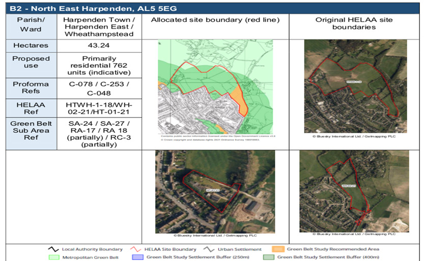
Figure 6: Proposed Site Allocation
Source: SDC
West Redbourn – the site as indicated in Figure 7, is 27.02ha land situated within the Redbourn Parish / Ward and its proposed use is primarily residential of 593 dwellings (indicative).
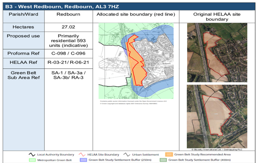
Figure 7: Proposed Site Allocation
Source: SDC
East St Albans – the site as indicated in Figure 8 is 21.69ha and is situated within Sandridge Parish / Ward. The proposed site is to provide 522 residential dwellings (indicative) (additional to adjoining permission).
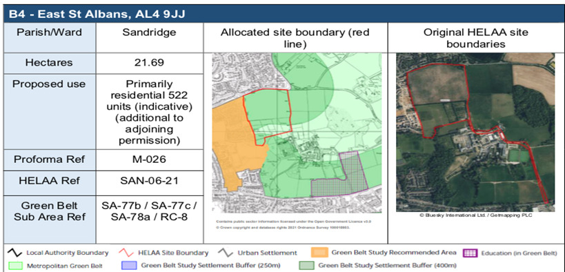
Figure 8: Proposed Site Allocation
Source: SDC
Glinwell, Hatfield Road – the site as indicated in Figure 9 is 20.85ha which is situated within Colney Heath Parish / Ward and it’s proposed to provide 436 residential dwellings (indicative).
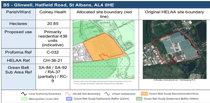
Figure 9: Proposed Site Allocation
Source: SDC
West of London Colney – the site as indicated in Figure 10, is 13.50ha, which is situated within London Colney / Park Street Parish / Ward and it’s proposed to provide 405 residential units (indicative).
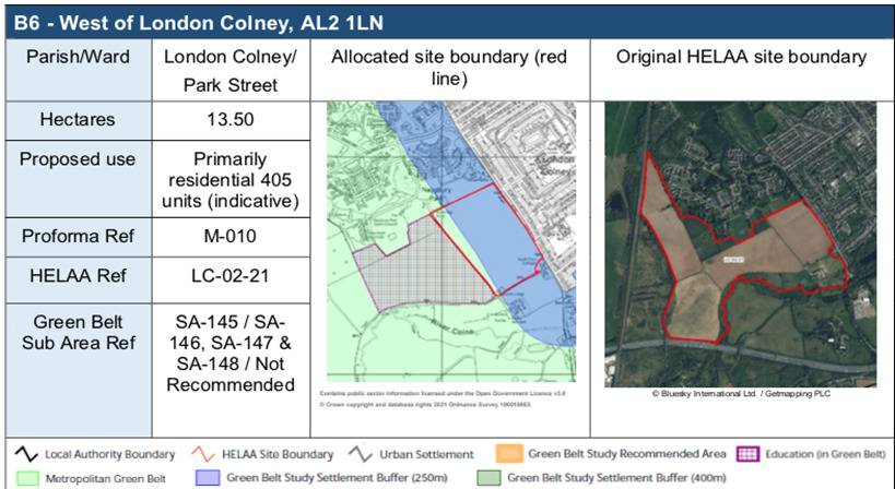
Figure 10: Proposed Site Allocation
Source: SDC
North West Harpenden –the site as indicated in Figure 11, is 12.19ha, which is situated within Harpenden Parish and it’s proposed to provide 293 dwellings (indicative).
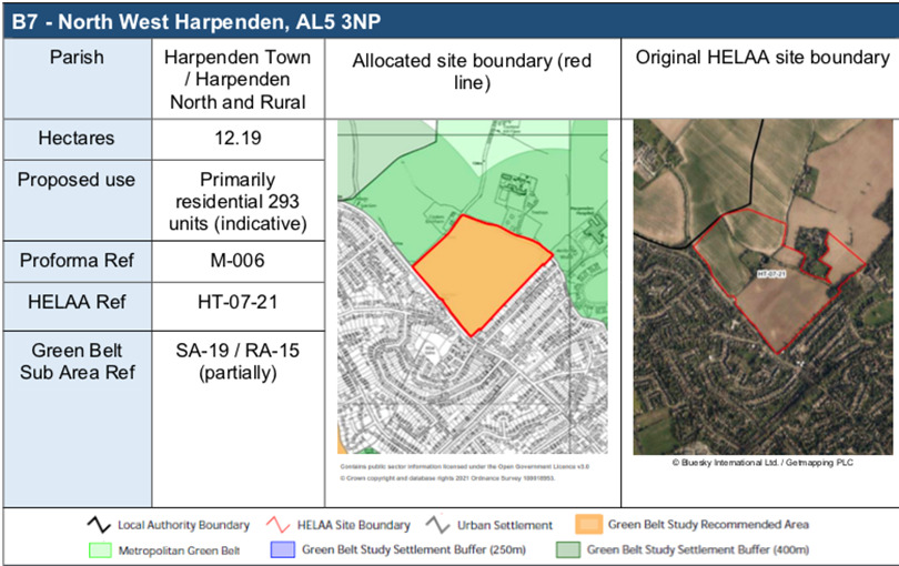
Figure 11: Proposed Site Allocation
Source: SDC
Harper Lane, North of Radlett – the site as indicated in Figure 12 is 11.40ha, which is located within St Stephens Parish and it’s proposed to provide 274 residential units (indicative).
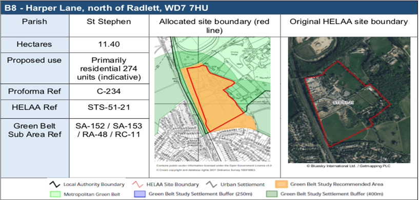
Figure 12: Proposed Site Allocation
Source: SDC
Large, Medium or Small sites
- Large Sites = 100 – 249 homes
- Medium and Small Sites = 5 – 99 homes
The Council noted that, the large, medium or small sites have the potential to be quicker to assemble and built out than the Broad Locations.
The red marked sites shown on Figure 13 shows the sites that have been brough forward for development across St Albans District Council that Landowners and Developers have submitted to the Council.
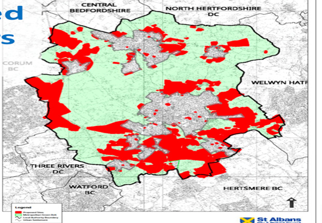
Figure 13: Sites Submitted by Landowners & Developers
Source: SDC
According to the Council published LDS dated September 2022, public consultation (Reg 18) on the draft Local Plan will begin from the 12th of July to September 2023, Pre-submission consultation (Regulation 19) is expected to commence from July to September 2024, whilst submission will be in December 2024. Examination is from December 2024 to November 2025 and the Local Plan is expected to be adopted by December 2025.
Share With Friends

