

Dorset Local Plan

by Jo Hanslip
Dorset Council was created on 1 April 2019 and replaced the District and Borough councils of East Dorset, North Dorset, Purbeck, West Dorset, Weymouth and Portland and Dorset County Council.
Dorset Council Local Plan Options Consultation (Regulation 18) commenced on 18 January and is running until 15 March 2021. The draft Local Plan contains proposals for future development in the Council area up to 2038.
Source: Dorset Local Plan (2021)
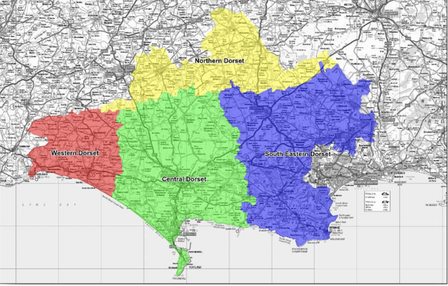
The Plan sets out a variety of spatial areas and ‘potential supply of new homes from option sites’ which as detailed also below.
South East Dorset Functional Area which include the areas of:
- Corfe Mullen (400 dwellings), Upton (0 dw), Blandford (900 dw), Ferndown and West Parley (1,100 dw), St Leonards and St Ives (0 dw), Swanage (150 dw), Verwood (100 dw), Wareham (0 dw), West Moors (170 dw), Wimbourne Minster & Colehill (495 dw), Alderholt (options under consideration), Lytchett Matravers & Lytchett Minster (200 dw), Sturminster Marshall (425 dw), Wool (200-300dw),
Central Dorset Functional Area which includes the areas of:
- Dorchester (3600 dw), Weymouth (550dw), Chickerell (0 dw), Portland (0 dw), Crossways/Moreton Station (6500 dw), Charminster and Charlton Down (340dw)
Northern Dorset Functional Area which include the areas of:
- Gillingham (70dw), Shaftesbury (0 dw), Sherbourne (1,200 dw), Stalbridge (430 dw), Sturminster Newton (0 dw),
Western Dorset Functional Area which includes the areas of:
- Beaminster (120 dw), Bridgport (0 dw), Lyme Regis (40 dw),
Source: Dorset Local Plan (2021)
A number of key questions are asked through the documents including matters such as:
- Are the functional boundaries drawn correctly and do they represent the areas housing and economic functions?
- Should green belt reviews take place?
- Where should the growth proposals occur?
- Approach in which species are protected
As at April 2019, the local authority 5 year land supply positions sat at:
- East Dorset – 4.91 years
- North Dorset – 4 years
- Purbeck 5.3 years and West Dorset, Weymouth & Portland – 4.83 years.
The Plan suggests that in the Bournemouth /Poole (South East and Central) Functional Areas draft Policy DEV3 proposes growth:
- at the county town of Dorchester, including through major urban extensions at Poundbury and North of Dorchester;
- at the major coastal resort of Weymouth, including through town centre regeneration and a major urban extension at Littlemoor;
- through regeneration within the settlements on Portland;
- through the significant expansion of the town of Chickerell and the larger village of Crossways / Moreton Station and the smaller-scale expansion of the larger villages of Charminster and Puddletown; and
- through windfall and infilling within existing settlements defined by local plan or neighbourhood plan development boundaries.
Across the central Dorset functional area, employment growth will be delivered through:
- infilling and intensification within existing employment sites; further commercial development at Poundbury;
- the development of allocated sites at Littlemoor and Crossways / Moreton Station; and
- substantial new development at North of Dorchester.
North Dorset Functional Area: growth is proposed in draft Policy DEV 4:
- at the market towns of Gillingham and Sherborne, including through major urban extensions to the south of Gillingham and the west of Sherborne;
- through the more modest expansion of Shaftesbury and the smaller market towns of Sturminster Newton and Stalbridge; and
- through windfall and infilling within existing settlements defined by local plan or neighbourhood plan development boundaries.
- Across the northern Dorset functional area, employment growth will be delivered through:
- infilling and intensification within existing employment sites;
- the southern extension of Gillingham and existing undeveloped land at Shaftesbury and Sturminster Newton; and
- development of land within the west of Sherborne development”
West Dorset Functional Area: growth is proposed in draft Policy DEV 5:
- In the western Dorset functional area housing growth will be delivered:
- at the market town of Bridport, including through a major urban extension at Vearse Farm;
- through the small-scale expansion of the coastal town of Lyme Regis and the smaller market town of Beaminster; and
- through windfall and infilling within existing settlements defined by local plan or neighbourhood plan development boundaries.
- Across the western Dorset functional area, employment growth will be delivered through:
- infilling and intensification within existing employment sites; the Vearse Farm extension to Bridport; and land at Beaminster
Draft Policy DEV 6 states that:
- In rural Dorset beyond the Green Belt and away from large built-up areas, towns and other main settlements, the ‘larger villages’ (in Tier 3 of the settlement hierarchy) will be the main focus for development.
- Within local plan development boundaries at the ‘larger villages’ residential, employment and other development will normally be permitted provided that:
- it accords with any site-specific policies for the expansion of the village in this local plan; or
- it contributes to meeting the needs of the local area; and
- it is at an appropriate scale to the size of the settlement.
- Within neighbourhood plan development boundaries, residential, employment and other development will only be permitted if it accords with the relevant policies in a neighbourhood plan
The spatial strategy set out in the Plan is summarised graphically in the Strategic Diagram at Figure 2.5 of the plan:
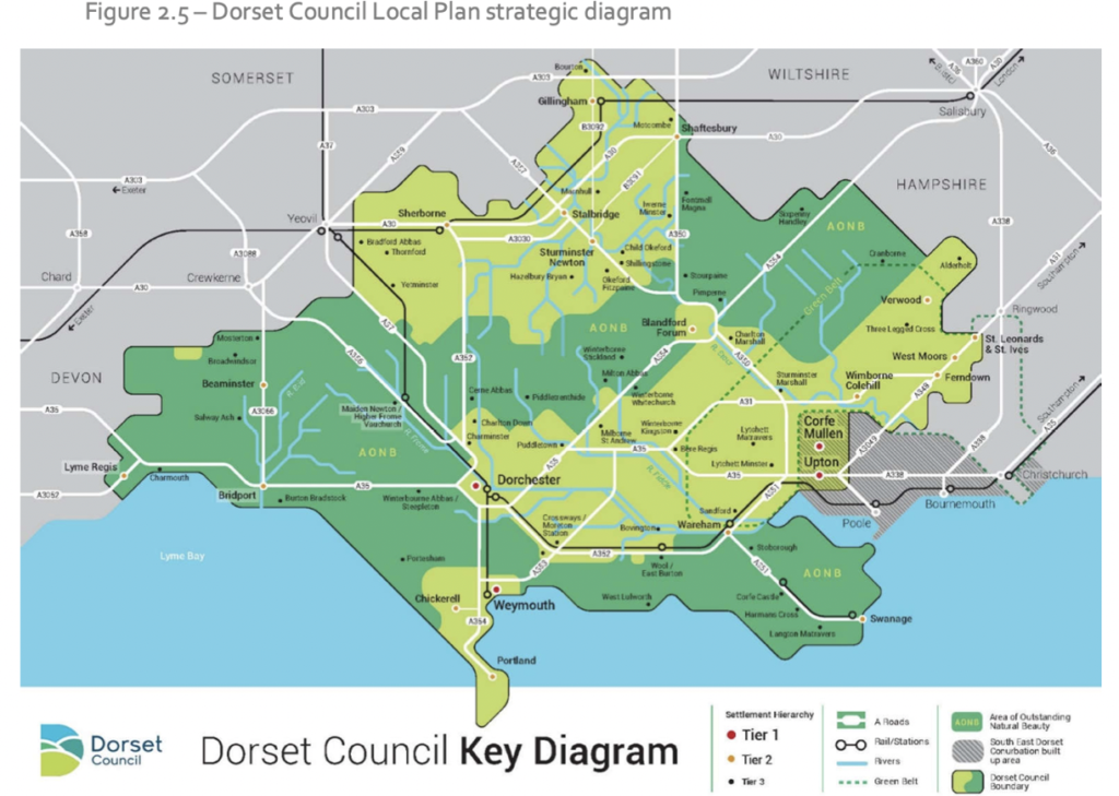
Source: Dorset Local Plan (2021)
A range of other polices are in the plan including:
- 10% biodiversity next gain from development
- Protecting heritage and landscape assets
- Ensuring geodiversity
- Achieving high quality design
- High standard of environment performance in buildings
- Ensuring amenity for all
- Pollution control
- Avoiding flood risk
- Provision of SUDS systems where possible
- Approach to self-build
- Gypsy, traveller and show people accommodation
- CIL and community infrastructure
- 30 % active electric vehicle charging spaces and 80% passive provision
- Low carbon and renewal energy
- Housing mix – 20% dwellings to be of Accessible and Adaptable standards
- Range of Affordable housing requirements based upon sones seeking between 25 and 40% provision and with tenure split of 10-30% affordable home ownership, 30% rent and 40% affordable rent.
Dorset Plan area is a large area with considerable issues to consider so it will be interesting to see how this plan evolves.
The Full plan and supporting material can be reviewed here:
Share With Friends

