

Bedford Borough Council Published Draft Local Plan (2040)
by Akeem Iginla
Following consultation in 2020 and 2021, Bedford Borough Council has published a new draft local plan. Public consultation was held for 6 weeks and ended on the 29th of July 2022. The local plan 2040 sets out where new homes and jobs will be in Bedford Borough up to 2040 in order to meet growth targets.
The Local Plan 2040 focuses mainly on a strategy to guide housing and employment growth to meet the government’s targets, and the infrastructure needed to support it. The Council are legally obliged to plan for a set number of homes around 1,355 per year to 2040.
The Plan’s strategy focuses first on new development in the urban area, including suitable previously developed ‘brownfield’ sites. The Plan then focuses on growth at sites just outside the urban area that will help deliver green infrastructure projects such as the Bedford River Valley Park, and at new locations on the East West Rail / A421 corridor that benefit from good access to planned rail stations.
The Plan also proposes two new settlements close to new railway stations on the proposed East West Rail line, one at the former brickworks at Kempston Hardwick as indicated in Figure 1 and at Little Barford to the east of the Borough where the East West Rail Line is planned to cross the East Coast Main Line as illustrated in Figure 2. There are also residential and employment allocations in rural Kempston.
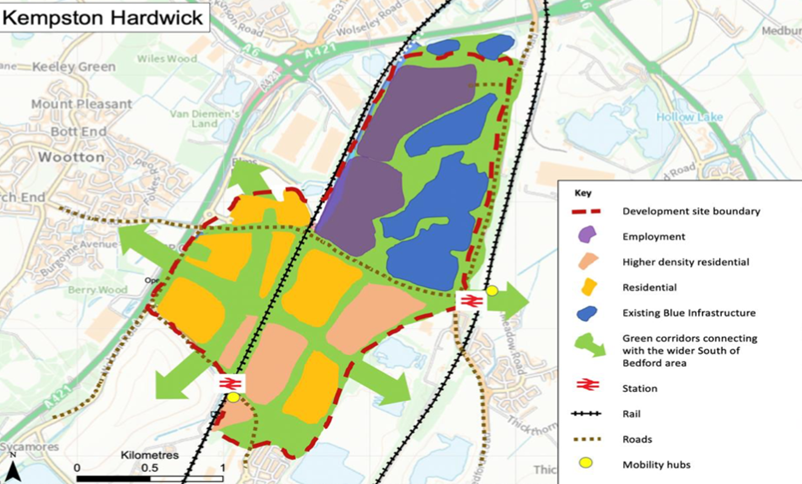
Source: Bedford Borough Council
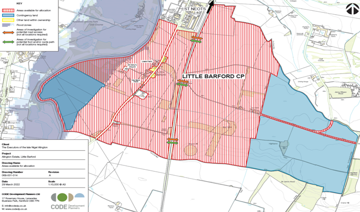
Source: Bedford Borough Council
The Plan also propose to develop lands at both the South and East of Wixam for residential and open space uses as indicated in Figure 3.
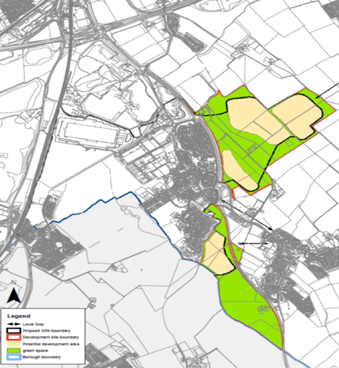
Figure 3; Lands South and East of Wixam
Source: Bedford Borough Council
Regarding employment opportunities alongside housing development, the Plan focuses on encouraging 26,700 high-skilled jobs, hence the planned number of sites across the borough.
Land at College Farm and DVSA sites in Shortstown will be developed for residential uses and open space as illustrated in Figure 4. According to the Plan, the development is dependent on the delivery of transport improvements which will need to be secured before development can take place in accordance with an agreed infrastructure Delivery Plan.
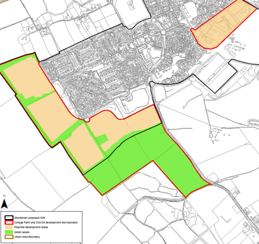
Source: Bedford District Council
The land at Abbey Field, West of Elstow is planned to be developed for residential use and to provide public access to existing urban open space, linking onto Elstow Corridor as indicated in Figure 5.
Other urban sites planned for residential developments includes:
- Former Peacocks Auction House in Newham Street, Bedford
- Land at Former Camford Works and Technology House on Ampthill Road
- Mayes Yard on High Street and Silver Street
- Former Bedfordshire Police Station
- Adjacent mixed-use block at Greyfriars Land, North Bedford
There is also a plan to create a new residential quarter for circa 700 homes adjacent to the station on Forte End Road. The site is a former industrial land and railway sidings located between the railway line and Marston’s Eagle Brewery which is already identified as a regeneration site and allocated within the Local Plan 2030 under Policy 12 as indicated in Figure 6:
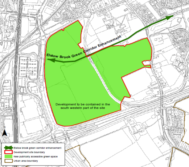
Figure 5: Land at Abbey Field
Source: Bedford District Council
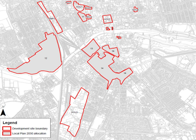
Figure 6: Local Plan 2030 Allocations
Source: Bedford District Council
The Council plan’s spatial strategy explains where new land will be allocated to provide the homes and jobs that are needed and builds on the strategy in the Local Plan 2030, taking into account allocations within that plan as well as others agreed by local communities in their neighbourhood plans. This approach is reflected on the key diagram indicated in Figure 3.
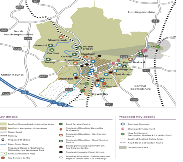
Figure 7; Local Plan 2040 Key Diagram
Source: Bedford Borough Council
Taking account of the responses to earlier consultations in 2020 and 2021, the Local Plan 2040 focuses on new growth in the following areas:
- First in the urban area with all suitable sites within the urban area boundary being allocated
- At two sites just outside the urban area that will help to deliver strategic green infrastructure projects alongside development (Bedford River Valley Park with a water sports lake and a section of the Bedford to Milton Keynes Waterway Park)
- At new locations on East West Rail and the A421 transport corridor particularly in the area south of Bedford and little Barford, which benefits from good access to new rail stations. These are illustrated in the below diagram with the combined proportion of sites allocated and proposed to be allocated by locations:
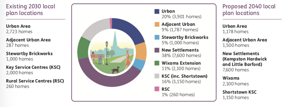
Figure 8: Allocation Diagram
Source: Bedford District Council
Distribution of growth Policy DS5(S)
In accordance with Policies DS3(S) and DS4(S), growth will be distributed as follows:
| Location | Dwellings | Employment land (ha) |
Within the urban area | 1,200 | 5 |
Strategic locations adjacent to the urban area which contribute to delivering the Forest of Marston Vale incorporating the Bedford Milton Keynes Waterway Park and the Bedford River Valley Park | 1,500 | 7 |
| Growth locations on the A421 transport corridor and with the potential for rail based growth | ||
South of Bedford including new settlement | 7050 | 70 |
Little Barford new settlement | 3800 | 4 |
Other employment sites | – | 50 |
Some development will take place beyond the plan period | 400 | |
Remaining rural area / villages | Completion of sites previously allocated in local plans and neighbourhood plans |
Share With Friends

